Land
New Mexico is Part of the Universe
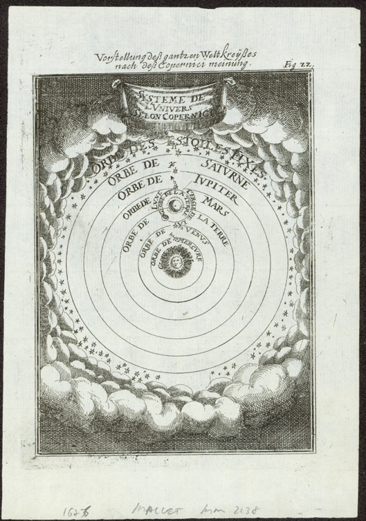
Manesson-Mallet was a soldier-engineer and the "Master of Mathematics" to Louis XIV. This cosmographical map of the solar system, reflecting the new ideas of Copernicus, Galileo, and Keppler, appeared in the 1684 German edition of his Description de l’Universe.... (1683). The lands that would become New Mexico are located on the Earth in the third orbit around the Sun.
Allain Manesson-Mallet, Vorstellung des ganzen Weltkreises. Copperplate engraving, Paris: Denys Thierry, 1684. Fray Angélico Chávez History Library NMHM, Map Collection, 1.0 1684
Map of the Western Hemisphere
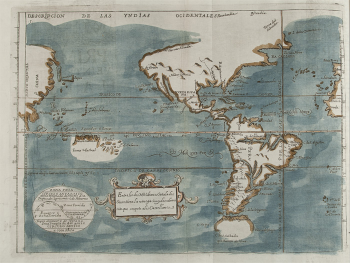
A Franciscan missionary in New Spain, Juan de Torquemada (c. 1557-1624), became interested in Mexico before the Conquest when he was appointed guardian of the monastery at Tlaxcala. Although Monarchia Indiana was first published in 1615, nearly every copy was lost in a shipwreck, and the work generally is known in this 1723 edition. The hand-colored map shows few details north of Mexico City, but includes New Mexico, the Sierra Nevada Mountains, and the Mississippi River.
Juan de Torquemada, Monarchia Indiana. Copperplate engraving, Madrid: Nicolas Rodriguez, 1723 (1615). Fray Angélico Chávez History Library NMHM, Rare Book Room 972 T687 v. 1
New Mexico: One of a Kind
La Fora was a captain in the Bourbon-Reforms-created Spanish Royal Corps of Engineers. He joined the expedition of inspection (1766-1767) of northern New Spain led by the Marquéz de Rubí that traveled approximately 7,600 miles. La Fora scientifically mapped various parts of northern New Spain. The Royal Engineers mapped only what they could observe and measure. They discounted hearsay information, even from resident Native peoples. This horizontal map of the Rio Grande is not one of the oYcial maps of the expedition and probably was created at the later date as a more artistic presentation piece when he was the corregidor (district magistrate) of Oaxaca.
Nicolás La Fora, Provincia de Nuevo Mexico. Hand-drawn, on vellum, 1778. Courtesy Rodrigo Rivero Lake, Art and Antiques, International
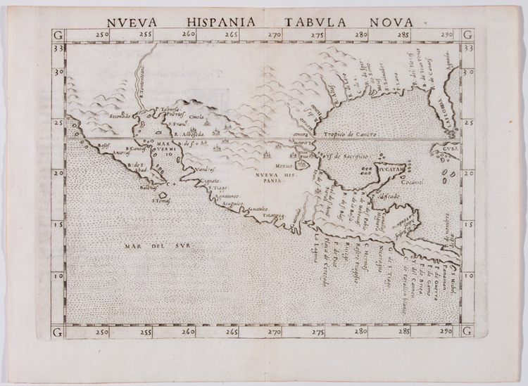
Where is New Mexico?
The first edition of this map, based on a similar 1548 map by Piedmontese Italian Jacopo Gastaldi, appeared in Ruscelli's publication of the ancient Greco-Roman geographer Claudius Ptolemy's La Geographia (1561, 1562) in latin and Italian. This second edition correctly has Baja California and the Yucatan as peninsulas, and the Mississippi River is shown as the de Spirito Santo. New Mexico is little more than "white space," except for some mountains, a few unnamed villages, and the legendary Seven Cities of Cibola rendered as "Ciuola."
Girolamo Ruscelli, Nueva Hispania Taabula Nova. Copperplate engraving, Venice, 1564. Courtesy Private Collection, Santa Fe
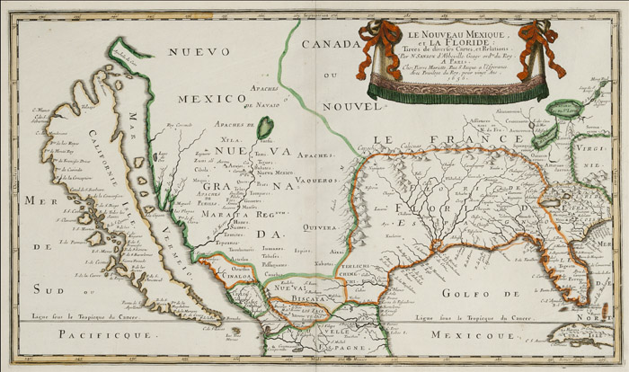
New Mexico takes Shape
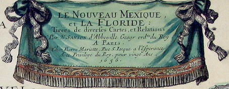
The mapping of the northern provinces of New Spain was still ambiguous in the first half of the seventeenth century, even for the royal geographer to Louis XIII, partially due to the lack of exact longitudes. while Florida and "Spanish" Louisiana are shown relatively correctly, California is represented as an island. In New Mexico, most pueblos are accurately displayed, but Santa Fe is on the wrong side of the Rio Grande, and the river erroneously flows into the "Vermillion Sea" (Gulf of California).
Nicolas Sanson d'Abbeville, Le Nouveau Mexique et La Floride. Copperplate engraving, Paris: Pierre Mariette, 1656. Fray Angélico Chávez History Library NMHM, Map Collection, 7.0 1656
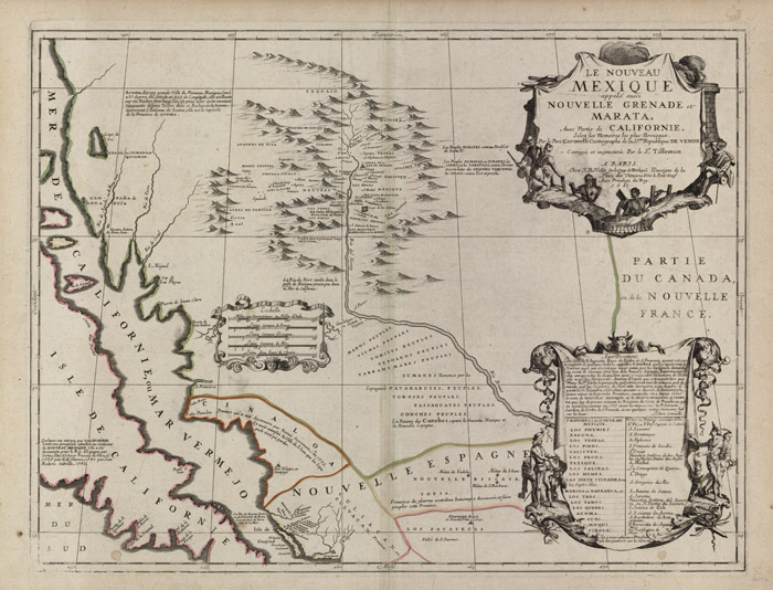
New Mexico's Name appiears
This rare 1742 map of the Rio Grande Valley of New Mexico originally done in 1688 by Coronelli, cosmographer of the Republic of Venice and royal cartographer to Louis XIV, accentuated its imortance as still the best and most exact large-scale map of the region. Although California is still depicted as an island, the map nevertheless shows the Spanish discoveries and pueblos along the upper Rio Grande and correctly records it as flowing into the Gulf of Mexico.
Vincenzo Maria Coronelli, Le Nouveau Mexique appelé aussi Nouvelle Grenade et Marata. Copperplate engraving, Paris: J.B. Nolin, 1742 [1688]. Courtesy Don Pierce, Santa Fe